Digital heat cadastre: the data foundation of municipal heat planning
This article explains what a digital heat cadastre does, how data collection under Section 11 WPG is governed, why data quality and data protection decide whether plans hold up, and what the 2026 WPG amendment changes for small municipalities.
The digital heat cadastre is the data foundation of every municipal heat plan. It is a georeferenced, database-driven GIS model in which every building and every grid section carries its own record. Based on 3D building models at Level of Detail 2, year of construction and renovation status, it computes heat demand at building level and condenses it into heat-density maps that mark suitability zones for heat networks. Data collection is governed by Section 11 of the Heat Planning Act, and Annex 1 lists eleven groups of relevant data. The biggest bottleneck is not the software but data quality: for the chimney-sweep registry data there is still no nationwide standard format. Cities over 100,000 residents had to submit their heat plan by 30 June 2026, smaller municipalities have until 2028, and around 10,700 municipalities are affected. The amendment of 27 May 2026 introduces a small heat planning procedure for municipalities under 15,000 residents, where digital energy maps serve as the decision basis. For municipalities and utilities, the priority now is to run the cadastre as a maintainable data product, not a one-off project.
Why the heat cadastre becomes a mandatory building block
A heat plan is only as good as the data it stands on. The Heat Planning Act has required municipalities to carry out area-wide heat planning since 1 January 2024, but the real effort lies in the data foundation. The digital heat cadastre brings building, consumption and grid data together in a georeferenced model and makes visible where a heat network is worthwhile and where a decentral supply makes more sense.
For you as a municipality or utility, that means: without a solid cadastre, every suitability assessment stays guesswork. The heat sector causes around 40 percent of CO2 emissions and accounts for over 50 percent of final energy consumption. This is where it is decided whether the local heat transition is built on facts or on assumptions.
- The law targets a greenhouse-gas-neutral heat supply by 2045 at the latest. Since 1 March 2025, new heat networks must be fed at least 65 percent from renewable energy or unavoidable waste heat.
- A heat plan under the WPG goes beyond a mere cadastre, yet without a solid data base no suitability zone can be marked out seriously. The legal framework and deadlines are covered in the article on municipal heat planning and the 30 June 2026 WPG deadline .
- Once the initial plan is done, the focus shifts from the deadline to quality. The cadastre becomes the tool that makes progress and implementation measurable in the first place.
What a digital heat cadastre does
A digital heat cadastre is a database-driven GIS model in which every building and every grid section carries its own record. On that basis, heat demand can be computed at building level and condensed into heat-density maps that mark suitability zones for heat networks.

- The basis is 3D building models at Level of Detail 2 (LoD2), combined with year of construction, building type and renovation status.
- A building-level, freely available space-heating demand model, such as the LANUV heat cadastre in North Rhine-Westphalia, delivers demand at high resolution and runs renovation scenarios through to 2045.
- Supplementary geodata such as solar potential, geothermal yield and grid availability allow an algorithmic assessment of every building in a municipality.
- Modern tools add an economic assessment layer on top that sorts heating-system alternatives such as heat pumps or solar thermal by ecological and economic criteria.
The data foundation under Section 11 WPG
Data collection is governed by law and at the same time the biggest bottleneck. Annex 1 of the WPG lists eleven groups of relevant data, from building structure through energy consumption to grid infrastructure. Section 11 WPG governs which bodies must supply data.
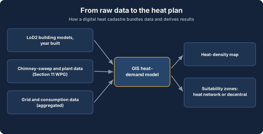
- Chimney-sweep registry data is a central source for the stock of heating systems and should be transmitted electronically and in machine-readable form where possible.
- Further data suppliers are grid operators, energy suppliers, federal and state authorities as well as possible future grid operators.
- Which bodies deliver at what quality and granularity varies considerably by region, which makes comparability harder.
Data quality, standards and data protection
The biggest weakness of many heat cadastres is not the software but the data quality. For the transmission of chimney-sweep data there is still neither a nationwide standard format nor a defined interface, which forces manual rework and media breaks.

- The Bundesrat sees significant added value in electronic data transmission with standardized templates and data formats across all federal states.
- Consumption data can be linked to individuals, so analysis usually happens aggregated at building or street-segment level, not at individual level.
- Missing or outdated year-of-construction and renovation data leads to demand estimates that can distort the later grid sizing.
- A cadastre is not a one-off project, it has to be kept up to date, otherwise the planning base ages with every renovation. How consumption data from remotely readable meters feeds in is shown in the article on remote reading under the Heating Costs Ordinance .
German and EU perspective
The legislator is responding to the data burden. The federal cabinet adopted an amendment to the WPG on 27 May 2026, expected to take effect at the end of the year, which lowers the effort for small municipalities and creates the heat planning data space as a nationwide data infrastructure.
For municipalities under 15,000 residents, a small heat planning procedure is introduced as an equal alternative. It omits the comprehensive inventory and potential analysis and the target scenario. Instead of a full analysis, digital energy maps serve as the decision basis, and documentation obligations drop significantly.
- Municipalities of 100,000 residents or fewer that use federal funding received a six-month extension to 31 December 2026.
- Around two thirds of the population live in municipalities already working on a heat plan. Among mid-sized municipalities between 10,000 and 100,000 residents, the completion rate stood at around 42 percent in early 2026.
- The heat cadastre is one building block of the digital energy transition. It ties into the same digitalisation as the decarbonisation roadmap for heat networks, described in the article on Section 32 WPG and the decarbonisation roadmap .
Challenges and risks
A digital heat cadastre does not solve the heat transition on its own. There is a risk that cadastres are built as an end in themselves, without implementation following. Seen in balance, the gain in predictability comes with some concrete risks.
- Data silos: as long as formats and interfaces between municipality, grid operator and state are not standardized, data exchange slows the integration.
- False precision: a high-resolution cadastre can suggest a precision the underlying estimates do not support. Model values quickly turn into apparent measurements.
- Dependencies: small municipalities without their own GIS competence rely on service providers and state data platforms. That creates lock-in to individual vendors.
- Ageing: without upkeep and clear responsibility, the cadastre loses value, and the expensively collected data ages with every renovation.
What municipalities and utilities should do now
The focus shifts from the deadline to quality. Whoever has completed the initial plan should treat the cadastre as a living data product, not a ticked-off project. Four steps take priority.
Four priority steps
-
Bundle data sources
Use state data platforms and the KWW data compass instead of tapping every source individually. That cuts effort and keeps the data comparable.
-
Insist on standards
Demand machine-readable formats and build interfaces to grid operators and chimney sweeps. Every media break avoided saves manual work and errors.
-
Build in data protection
Process consumption data in aggregated form, set access rights clearly and collect only the granularity the planning needs, in line with the GDPR.
-
Secure ongoing upkeep
Set up the cadastre as a maintainable system and name fixed responsibilities for its upkeep, so it does not age with the first wave of renovations.
The heat cadastre is not a standalone topic but part of the digital heat transition. It ties into the same control logic as modern district-heating networks, described in the article on cold district heating and its digital control . Only data base, network planning and operation together give the full picture.
Further reading
Frequently asked questions
A digital heat cadastre is a georeferenced, database-driven GIS model in which every building and every grid section carries its own record. Based on 3D building models at Level of Detail 2 (LoD2), year of construction and renovation status, it computes heat demand at building level and condenses it into heat-density maps. These show where a heat network is worthwhile and where a decentral supply makes more sense. The heat cadastre is the data foundation of municipal heat planning, but it does not replace the heat plan itself.
Annex 1 of the Heat Planning Act lists eleven groups of relevant data, from building structure through energy consumption to grid infrastructure. Section 11 WPG governs which bodies must supply data. A central source is the chimney-sweep registry data on the stock of heating systems. Further data comes from grid operators, energy suppliers and federal and state authorities. Which bodies deliver at what quality varies considerably by region.
Cities with more than 100,000 residents had to submit their heat plan by 30 June 2026, smaller municipalities have until 30 June 2028. Around 10,700 municipalities are affected in total. Municipalities of 100,000 residents or fewer that use federal funding received a six-month extension to 31 December 2026. According to the Competence Center for Municipal Heat Transition, around 71 percent of large cities had completed their planning by April 2026.
The federal cabinet adopted an amendment to the Heat Planning Act on 27 May 2026, expected to take effect at the end of the year. For municipalities under 15,000 residents, a small heat planning procedure is introduced as an equal alternative. It omits the comprehensive inventory and potential analysis and the target scenario. Instead of a full analysis, digital energy maps serve as the decision basis, and documentation obligations drop significantly.
Consumption data can be linked to individuals, so analysis in the heat cadastre usually happens aggregated at building or street-segment level, not at individual level. That keeps the planning meaningful without exposing single households. Under the GDPR, municipalities should build in data protection from the start, set access rights clearly and collect only the granularity the planning actually needs.
Let's collaborate
One contact, a team behind it
Thirty minutes on what you're working on, whether grid, metering, market processes, IT architecture or AI. Afterwards you'll know how we'd approach it and who would sit at the table.
Energy and measurement technology since 2010 · innobu GmbH since 2014 · Based in Schleswig-Holstein, Germany
Whoever pitches also delivers: whoever leads the first call stays your contact right through to the steering committee, with established partners in the project. Direct: info@innobu.com