AI-assisted drone inspection of power grids: BVLOS and automatic image recognition
This article sets out seven threads: what drone- and AI-assisted grid inspection is about, how the workflow runs from flight planning to maintenance, what BVLOS flights make possible and which EU rules apply, what European practice looks like at TenneT, Netze BW and other operators, what the technology delivers for safety, cost and speed, which challenges and risks remain, and what grid operators should do now.
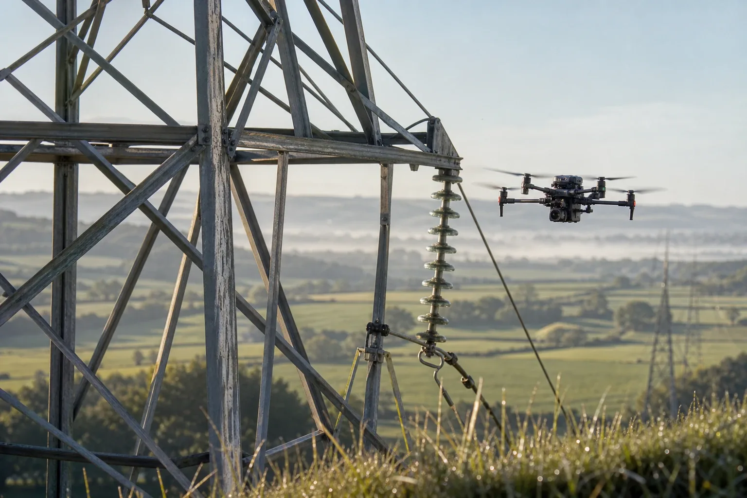
European transmission and distribution grid operators increasingly inspect overhead lines, pylons and substations with drones instead of helicopters and manual climbing, and analyse the images with computer vision. The reason is practical. The German transmission grid is around 35,000 kilometres long and only 0.4 percent underground, so almost entirely overhead, the distribution grid measures around 1.68 million kilometres across roughly 880 operators. A drone flies a pylon up to 70 metres tall in minutes and delivers images from any angle, without anyone climbing and without switching the line off. Image-recognition models, often based on object detectors, automatically identify insulators, fittings, corrosion, missing parts and bird nests and prioritise the findings, which experienced engineers review before any work order. The biggest lever comes from flights beyond visual line of sight (BVLOS), because they cover whole line corridors in one go; in the EU they fall into the specific category of drone regulation 2019/947 and require an operational authorisation from the national aviation authority, in Germany since 1 January 2026 based on the SORA 2.5 methodology, with a processing time of around two to four months. Netze BW inspects its 110 kV lines by drone and LiDAR under the NETZinspect programme, TenneT and Jade University of Applied Sciences run an InnovationLab at the Maade substation in Wilhelmshaven until 2028, and ED Netze flew around 25 kilometres of overhead line with roughly 100 pylons in three hours BVLOS with FlyNex back in 2021. International comparisons show cost advantages of roughly 50 to 75 percent over helicopters. The limits lie in model errors, the effort for clean training data, the data volumes including data-protection questions, and the time approvals take. For grid operators that means: start small, tackle the approval early, define a data strategy and learn with partners.
Why it matters: AI and drones take over grid inspection
European grid operators increasingly inspect their overhead lines with drones rather than helicopters, binoculars and manual climbing, and they no longer review the images by hand but with trained image-recognition models. The reason is sober and practical. The German transmission grid is around 35,000 kilometres long and only 0.4 percent laid underground, so almost continuously built as overhead lines. The distribution grid measures around 1.68 million kilometres and runs roughly 80 percent below ground, yet the remaining overhead lines in the medium- and low-voltage range are exactly the assets that need regular checks from the air.
The pressure rises from two sides at once. The grid build-out for the energy transition increases the number of pylons, lines and substations that need checking, while experienced field engineers retire and skilled staff grow scarce. A drone flies a pylon up to 70 metres tall in minutes and delivers high-resolution images from any angle, without anyone having to climb. Corrosion, loose parts, damaged insulators and vegetation growth can be captured this way from a safe distance.
That shifts where the real work sits. The bottleneck is no longer the field inspection but the analysis of the images, and that is where the AI comes in. A single large flight produces thousands of photos whose manual review used to be too costly. Image-recognition models now take on the first pass, flag anomalies and pre-sort the material. How AI fits into grid control and operations is covered in our piece on agentic AI in energy utilities; inspection is one of its most tangible building blocks.
It matters to see this as a tool, not a self-runner. Drones and image recognition take the dangerous and dull work off staff, but they do not replace expert judgement on a finding. The value appears only when the flight, the analysis and the maintenance are organised as one continuous process rather than a loose collection of images.
How the AI-assisted inspection works
The workflow runs in several stages, from flight planning to maintenance, and forms a recurring cycle. It begins with a route and a risk assessment and ends with a prioritised finding that feeds the maintenance plan. In between sit the flight, the data capture and the automatic image analysis that gives the technology its name.

The flight itself runs increasingly automated on pre-planned routes around pylons and along the conductors. A drone usually carries several sensors: a high-resolution RGB camera for visible damage, an infrared camera for overheated spots on clamps and connectors, and often LiDAR, which delivers centimetre-precise 3D point clouds of the corridor. From those point clouds, distances to vegetation can be calculated and storm-prone trees spotted early.
The AI image analysis is the core. Object detectors, often from the YOLO family, first recognise the components of a pylon and then check them for typical defects: corrosion, missing or shifted fittings, damaged insulators or bird nests. The model marks anomalies with boxes and assigns a defect class, so that thousands of images turn into a manageable list of spots worth checking. This pre-sorting is the real time saving over a pure visual inspection.
Validation comes before any work order. Experienced grid engineers look at the flagged spots, discard false positives and rank real defects by urgency. Only then do the findings enter asset management and trigger maintenance or repair. With every round the data set also grows, which improves later flights and model training, which is why the process is best understood as a cycle, not a one-off action.
What BVLOS makes possible, and which rules apply
The biggest lever lies in flights beyond visual line of sight, BVLOS for short. Only then does a drone fly a whole line corridor in one go, instead of being moved from site to site. This is the jump from point inspections of single pylons to continuous corridor inspection, and this is where aviation regulation becomes the deciding factor.

In the EU such flights fall into the specific category of drone regulation 2019/947 and require an operational authorisation from the national aviation authority, in Germany the Luftfahrt-Bundesamt (LBA). There are three routes to authorisation: standard scenarios (STS-01 for flights within sight, STS-02 for BVLOS over sparsely populated areas with certified class C5 or C6 drones), predefined risk assessments (PDRA) and the individual SORA risk analysis. Which route fits depends on the drone, the area and the flight profile.
Since 1 January 2026 new applications must use the updated SORA 2.5 methodology. Processing takes around two to four months depending on the maturity of the application and the operator's experience, which calls for lead time. In parallel, Europe's traffic management for drones is taking shape, the so-called U-space under regulation EU 2021/664, which bundles geo-awareness, flight authorisation and tracking. It is being rolled out step by step, with EU-wide coverage expected by around 2027.
For grid operators that means a double view. Technically, corridor inspection has long been feasible; legally, the authorisation decides reach and pace. Anyone planning BVLOS should treat the approval process as its own project strand and start early, often with a specialist provider that guides the application.
European practice: TenneT, Netze BW and other operators
The technology is no longer a future promise but runs at several operators in regular service and in large research projects. Netze BW, a subsidiary of EnBW, inspects its 110 kV lines by drone under the NETZinspect programme and increasingly analyses the images automatically. Each operations centre keeps two trained pilots and one drone for this, and LiDAR delivers centimetre-precise 3D scans of the corridors to spot growth and storm-prone trees early.

In January 2026, TenneT and Jade University of Applied Sciences opened an InnovationLab at the Maade substation in Wilhelmshaven. On a test field of around 900 square metres with voltages up to 300,000 volts, they research drones, sensors with LiDAR as well as UV, IR and RGB components, and AI-assisted data analysis under real conditions until 2028. TenneT managing director Tim Meyerjürgens names the core advantage plainly: drones can carry out their work close to equipment that is in operation without power lines having to be switched off for it. The findings are meant to transfer to further sites.
Smaller utilities are active too. The Schwerin utility WEMAG monitors overhead lines, pylons and grid equipment by drone with high-resolution cameras, and MITNETZ STROM ran an early pilot with the service provider FlyNex. Back in 2021, ED Netze together with FlyNex flew around 25 kilometres of overhead line with roughly 100 pylons in just three hours BVLOS, an early European example in which the subsequent AI analysis automatically detected damage and bird nests. Such projects show that the building blocks exist and can be assembled into a dependable process, much like the digital twin for utilities, which makes grid data usable for operational planning.
What the technology delivers: safety, cost and speed
The benefit is measurable and touches several fields at once. The most immediate is safety: where a drone flies, nobody has to climb a 70-metre pylon, and the need for risky helicopter flights falls. On top comes availability, because the inspection runs in live operation without the line being switched off, which avoids costly supply interruptions.
The economics are clear. International experience shows that drone inspections are markedly cheaper per unit of line than helicopter flights, with savings of roughly 50 to 75 percent. The US utility Georgia Power reported around 60 percent lower annual cost together with better data quality. These figures come from other markets and do not transfer one to one to Europe, but they show the direction.
The perhaps most important gain lies in data quality. Drones deliver georeferenced, repeatable images instead of a subjective visual check, and from that data base predictive maintenance can be built: photographing the same pylon year after year from the same angle reveals slow changes early. That links inspection to the wider digitalisation of distribution grids, which our piece on digital distribution grids sets in context.
Challenges and risks
The technology does not solve everything on its own, and a sober look belongs here. Image-recognition models produce errors in both directions, false alarms as well as missed defects, and weather, lighting and camera angle visibly affect the hit rate. That is why the review by experienced engineers stays mandatory, and the efficiency gain appears only after this validation, not before it.
Underneath sits a data problem. AI models need cleanly labelled training data, that is, images in which components and defects are correctly marked. This labelling is laborious and demanding, and without a solid data base the detection stays imprecise. On top comes the sheer volume: thousands of images per flight have to be stored, managed and versioned, and georeferenced aerial images over private land raise data-protection questions under the GDPR that need to be settled.
Regulation remains a hurdle too. BVLOS approvals cost time, and operators need trained staff and defined processes, otherwise the potential gain evaporates. Where AI makes findings about critical infrastructure, governance also comes into view, for instance in the context of the EU AI Act, which our piece on the high-risk deadlines of the EU AI Act sets in context. Anyone treating drone, AI and approval as separate building sites risks ending up without a continuous process.
What grid operators should do now
The most important recommendation is to start step by step and to take the data base seriously from the outset. Anyone starting today should first inspect a defined line section within visual range, try out the automatic image analysis and document the processes, before the jump to BVLOS and large corridors follows. That way experience and reliable metrics build up without going straight for the most demanding procedure.
The approval belongs early on the agenda. SORA 2.5 and the LBA procedure need several months of lead time, and specialist providers can guide the application. In parallel, a data strategy has to be set: a central image database, clear validation steps and defined interfaces to asset management, so that images turn into work orders in the end and not just data heaps.
Finally, it pays not to learn alone. Research partnerships such as the InnovationLab by TenneT and Jade University and Europe-wide consortia of grid operators share experience and training data, which makes the models better faster than any single operator could. Drone inspection is therefore less a single tool than a building block of a continuous digitalisation of grid operations, one that unfolds its value only in the interplay of technology, data and process.
Further reading
Frequently asked questions
Drones capture high-resolution images of pylons, lines and substations from any angle, without engineers having to climb structures up to 70 metres tall or lines having to be switched off. They lower the risk to staff, replace expensive helicopter flights and deliver georeferenced, repeatable images as a basis for predictive maintenance. International comparisons cite cost advantages of roughly 50 to 75 percent over helicopters. The real work shifts from the field inspection to the analysis, which automatic image recognition increasingly handles.
BVLOS stands for Beyond Visual Line of Sight, meaning flights outside the pilot's direct view. That is how a whole line corridor can be flown in one go. In the EU such flights fall into the specific category of drone regulation 2019/947 and require an operational authorisation from the national aviation authority, in Germany the Luftfahrt-Bundesamt. There are three routes: standard scenarios (STS-01, STS-02), predefined risk assessments (PDRA) and the individual SORA risk analysis. Since 1 January 2026 new applications must use the SORA 2.5 methodology, and processing takes around two to four months.
Image-recognition models detect components and typical defects such as corrosion, loose fittings or missing parts and flag anomalies. They also produce errors in both directions, false alarms as well as missed defects, and weather, lighting and camera angle affect the hit rate. That is why experienced grid engineers review the findings before any work is ordered. Quality depends heavily on cleanly labelled training data. The AI speeds up the review of thousands of images but does not replace expert judgement.
Netze BW inspects its 110 kV lines by drone under the NETZinspect programme, uses LiDAR for centimetre-precise 3D scans of the corridors and increasingly analyses the images automatically; each operations centre keeps two trained pilots and one drone. TenneT and Jade University of Applied Sciences run an InnovationLab at the Maade substation in Wilhelmshaven until 2028, researching drones, sensors and AI analysis. WEMAG monitors overhead lines by drone, MITNETZ STROM ran an early pilot, and ED Netze flew around 25 kilometres of overhead line BVLOS with FlyNex back in 2021.
Exact figures vary by grid and provider. International comparisons show that drone inspections are markedly cheaper per unit of line than helicopter flights, with savings of roughly 50 to 75 percent. The US utility Georgia Power reported around 60 percent lower annual cost together with better data quality. There are indirect gains too: fewer shutdowns, less dangerous work at height and a reusable image database. Drones move the effort from the flight to the data analysis, which the AI takes on.